Fort Collins Weather

This page includes small case studies on Front Range snowstorms
affecting Fort Collins
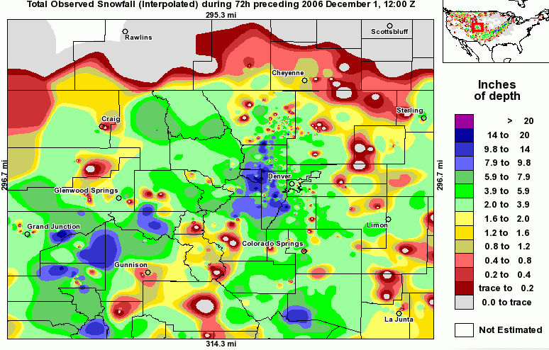
Moderate snow occurred in the evening hours of November 28th (00z to 06z
November 29th). The snow total was 7.4"
500mb
loop
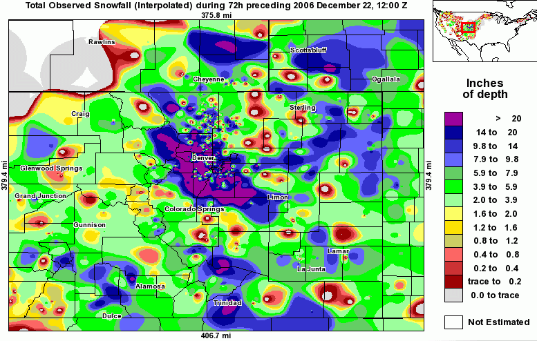
Moderate to heavy snow and blizzard conditions occurred in and around
Fort Collins in this classic Front Range blizzard. Snow fell for nearly
24 hours, from about 10:00AM on December 20th to about 8:00AM on
December 21st (17z December 20 to 15z December 21) The snow total was
19.9". Many areas of the foothills and mountains got over 3 feet of
snow.
500mb
loop
500mb
loop including a longer time span
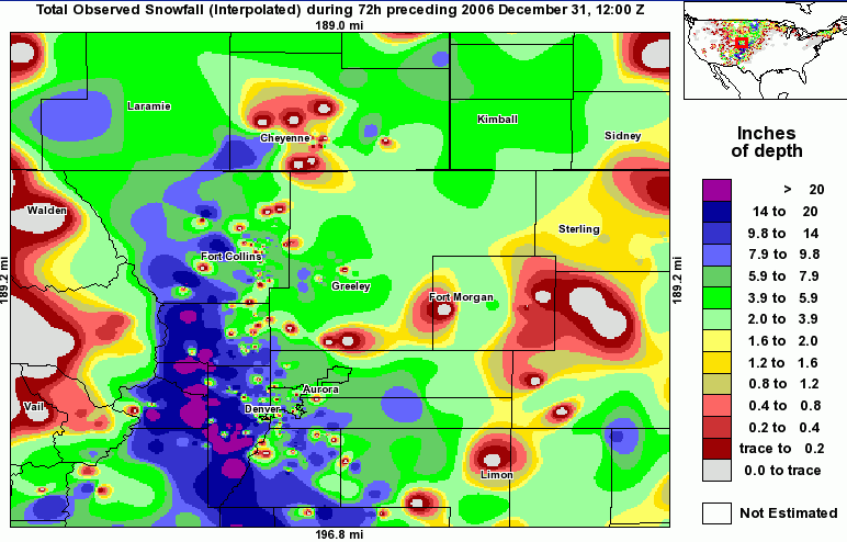
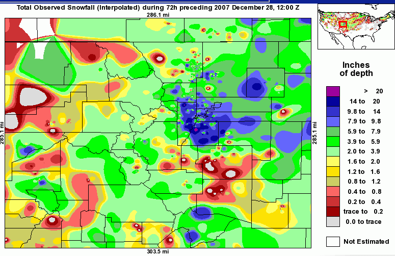
Heavy snow, more than 1" per hour, occurred in the evening and nighttime
hours of December 28th (00z to 06z December 29). The snow total was
8.5". This was a classic blizzard for the southern Front Range area,
northern New Mexico, and western Kansas. This was the second blizzard in
8 days for the Front Range area, although Fort Collins did not
experience the strong wind or extreme snowfall as did the southern
areas.
500mb
loop
Moderate snow occurred in the overnight hours of November 20th and 21st
(07z to 13z November 21) The snow total was 4.6".
500mb
loop
1.2" of snow fell on Christmas. Then a second storm system with moderate
snow occurred from the 4:00AM to about 4:00PM on December 27th (11z to
23z). The snow total was 6.2" on December 27th.
500mb
loop
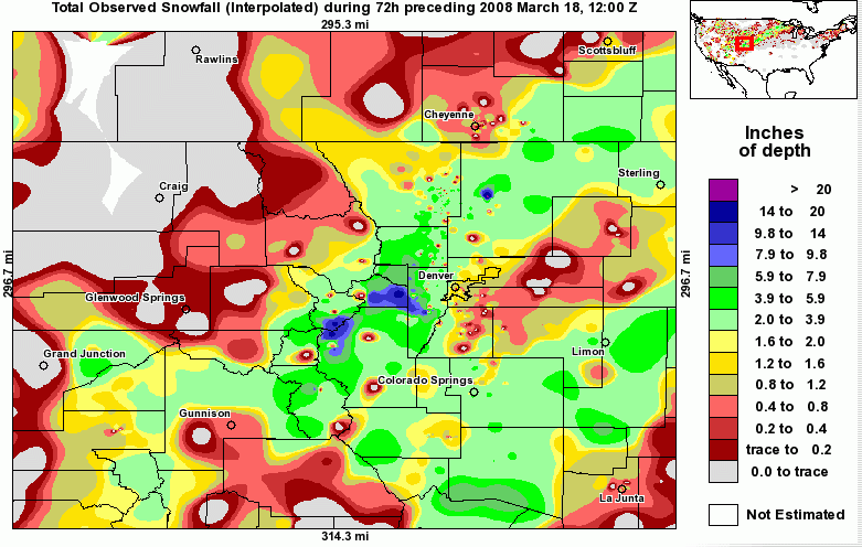
3.8" of wet snow occurred in the evening and nighttime hours of March
16th (01z to 06z March 17)
500mb
loop
500mb
loop with a longer time span
0.3" of snow fell on December 3rd. Then 6.3" of new snow fell in the
overnight hours, 12:00 midnight to 6:00AM, on December 4th (07z to 13z).
This storm was associated with a strong WNW to NW upper level flow
througout the storm, with an arctic cold area in North Dakota, referred
to as an arctic trough type storm.
500mb
loop
Link to alternate snowfall total plot"
7" of snow fell in the early morning through about noon on March 26th.
Buckhorn Mountain, at 8320 feet, reported 19.9" of snow. This was a
classic Front Range and southwestern Kansas blizzard.
250mb
loop
500mb
loop
700mb
loop
850mb
loop
SLP
loop
mesoscale
surface map loop
Radar
loop
Surface
analysis loop
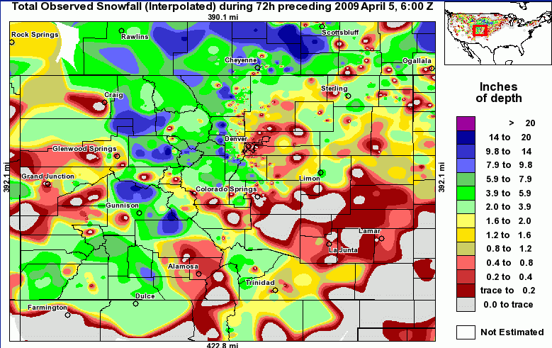
5.2" of snow fell on the morning of April 4th. This storm affected
Denver with less snow than Fort Collins.
250mb
loop
500mb
loop
700mb
loop
850mb
loop
SLP
loop
mesoscale
surface map loop
Radar
loop
Surface
analysis loop
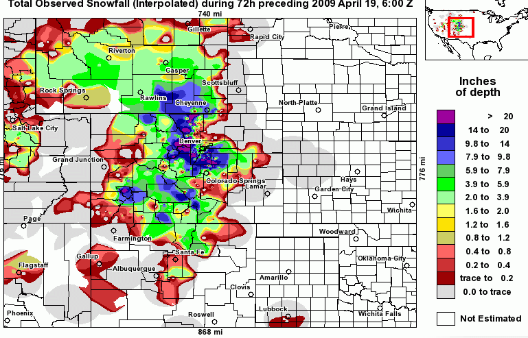
A cold rain occurred at Fort Collins for 2 to 3 days. Wet snow occurred
for several hours on April 17th, both in the morning and in the evening.
This wet snow totaled only 2.3" even though it contained a lot of
water, more than 0.2" of water. The rain total was over 2" because it
was so steady. In the nearby mountains and foothills, that is, areas
over 7000 feet elevation, all snow fell for 2 or 3 days and piled up
several feet. Perhaps 12 to 24" of wet snow fell on Horsetooth Mountain
at 7255 feet. Buckhorn Mountain, at 8320 feet, only 14 miles from Fort
Collins, reported a whopping 47.8" of snow. This was a classic heavy
snowfall for the foothills and mountains.
250mb
loop
500mb
loop
700mb
loop
850mb
loop
SLP
loop
mesoscale
surface map loop
Radar
loop
Surface
analysis loop
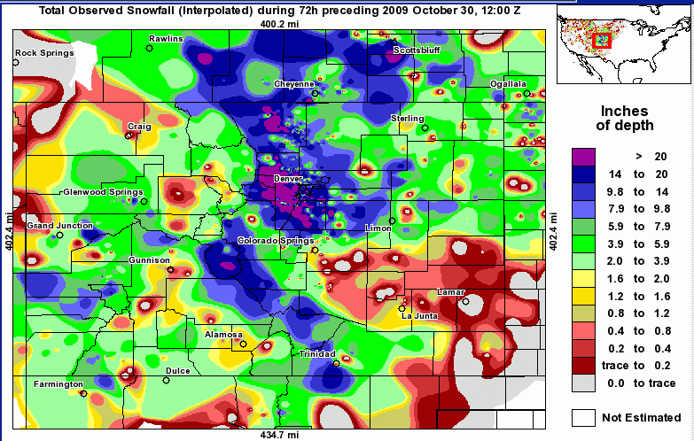
Light rain changed to snow on the evening of Tuesday October 27. 5.5" of
snow was on the ground on the morning of October 28. By October 29, a
total of 21.6" had fallen. Moderate winds accompanied this storm, all
except for the northeast plains of Colorado, where some spots of
blizzard conditions occurred. There were two main periods of snow at
Fort Collins. A deep low at all levels of the atmosphere was created
near the Four Corners as a strong northwesterly to northerly jet streak
was situated in the Pacific Ocean and the Pacific Northwest and Great
Basin. This deep low sat near the Four Corners for a long time. There
was not a surface high in South Dakota or Minnesota with this storm, as a
weaker low went near Montana and Saskatchewan.
250mb
loop
500mb
loop
700mb
loop
850mb
loop
SLP
loop
mesoscale
surface map loop
Radar
loop
Surface
analysis loop
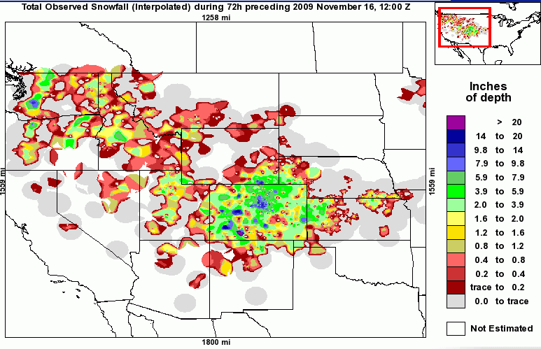
Moderate to heavy snow occurred over a few hours on the night of
November 14, and there was a total of 5.5" on the morning of November
15.
250mb
loop
500mb
loop
700mb
loop
850mb
loop
SLP
loop
mesoscale
surface map loop
Radar
loop
Surface
analysis loop
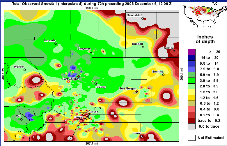
Moderate to heavy snow occurred over a few hours on the night of
December 5 to the morning of December 6, and there was a total of 9.4"
by the evening of December 6. The snow was very light and fluffy during
the daytime hours of December 6 as well as December 7 with very cold
temperatures.
250mb
loop
500mb
loop
700mb
loop
850mb
loop
SLP
loop
mesoscale
surface map loop
Radar
loop
Surface
analysis loop
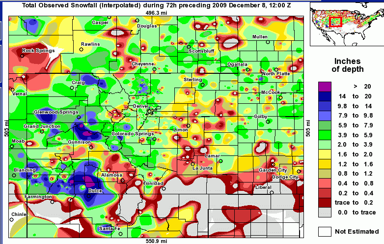
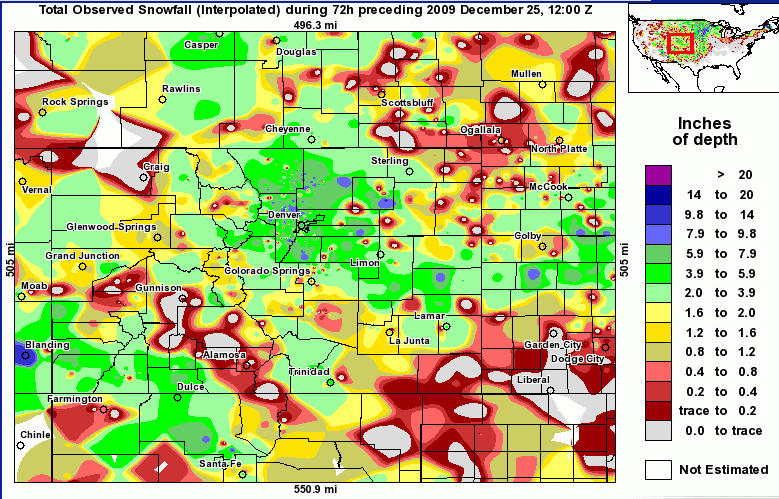
Fort Collins got 6.9" of snow on late December 22, December 23 and early
on December 24. This was part of the great Christmas storm of 2009,
affecting all of the Midwest.
300mb
loop
500mb
GFS loop
500mb
loop
700mb
loop
850mb
loop
Surface
analysis loop
mesoscale
surface map loop
Radar
loop
Radar
loop -Colorado area
The purpose is to provide high quality information on historical storms
and provide links to weather information.